


The wind had been building all morning. What had started as a gentle 10-knot breeze at sunrise was now a sustained 30 knots. Despite its deep gunwales, our little 15-foot aluminum dinghy is not the most comfortable place to be on the open ocean in high winds and a six-foot swell. Yet, after a run in to Queen Charlotte City for perishables, that was exactly where we found ourselves. We were exiting Skidegate Narrows at its western end and expected that another 30 minutes would put us back aboard Explorer, our 60-foot wooden trawler (cover model for the April 2002 issue of PassageMaker). The wind-whipped spray collecting on my glasses added to the visibility challenges, but I began to make out a boat circling about a half mile offshore. It looked eerily like Explorer, but I dismissed that thought, knowing we had left her safely anchored some five miles from here.

The Queen Charlottes, or, Haida Gwaii
Skidegate Narrows separates Graham Island to the north and Moresby Island to the south. These two islands form the bulk of Haida Gwaii, a group of about 200 islands off the rugged west coast of Canada, as far north as you can go before re-entering U.S. territory at Southeast Alaska. On our charts, this archipelago looked deceptively close to civilization, but we quickly found that a sea voyage to Haida Gwaii is not for the ill-prepared.
Our journey was the culmination of years of dreaming and planning. The remote and mostly untraveled west coast of Haida Gwaii had called us most strongly, and those waters required a special vessel, well found and stout, capable of handling the extremes of both weather and currents. Explorer fit that bill, and we—my good friend Brian McWatters and I—cast off on a fine morning in mid-July 2017. We were bound for waters with no cell phone coverage, no marinas, no towns or villages, scant sources for potable water, and no assistance close by. The Canadian Coast Guard has a well-equipped station in Skidegate, but in the case of an emergency, their travel time by boat would be measured in many hours—even then, only weather permitting.

While some local boaters may visit the northwestern part of Haida Gwaii, few venture farther south along the coast of Moresby. There, many of the bays are uncharted, anchorages are few, rainfall totals upwards of 60 inches per year, and the shores are exposed to the wild winds that the Pacific Ocean delivers at will. Our capable and experienced crew had all these elements in mind, and when we slipped our mooring in Van Isle Marina, Sidney, B.C., Explorer was suitably provisioned for the coming voyage. We would not be back until early September.
Starting Out

The first part of our journey would be devoted to positioning ourselves for the crossing of Hecate Strait, which separates Haida Gwaii from the islands that hug the mainland of British Columbia. Where we would make the westward crossing would depend almost exclusively on the weather forecast. Hecate Strait is relatively shallow (even 20 miles offshore there are large areas where there is less than 100 feet of water), and subject to strong winds and currents as well. Crossing the strait can be quite dangerous and should only be attempted with a true understanding of the capabilities of your vessel and full knowledge of developing weather systems.
Our overarching plan, given the furies that Hecate can summon, was to make the crossing as quickly as possible. A glance at the charts suggested a likely path: up the Inside Passage to the top of Princess Royal Channel, just south of Hartley Bay, and then out through Otter Passage along the southeast end of Banks Island. This would set us up for a straight shot across the strait to Sandspit, a route that would have us in unprotected waters for just under 70 nautical miles. Underway, at our usual 1400 rpm and making 7.8 knots, Explorer could make the run in about nine hours. (She sips diesel at about four gallons per hour.)
Explorer is equipped with the technological wizardry that enables us to gather a remarkable variety of data on marine weather and sea conditions. As we journeyed north we kept a close watch on conditions on Queen Charlotte Sound and Hecate Strait.

As it turned out, our vigilance with regards to weather developments presented us with another option. We had put in three long, 14-hour days since leaving Sidney, and with the added help of an early (7 a.m.) slack tide at Seymour Narrows, we were tucked in comfortably at Farewell Harbour in the Broughton Archipelago. It was the evening of July 19 and the weather gods were smiling on us so far. We assessed upcoming conditions on Queen Charlotte Sound and began to give serious consideration to an alternate route: one that would entail traveling 50 miles up Queen Charlotte Strait and then making an open-ocean run of 140 miles, bearing northwest for Rose Harbour, which is located at the most southerly part of Moresby Island. The southern half of Morseby is entirely made up of Gwaii Haanas National Park.
It was clear to us that evening that conditions for such a crossing were excellent. In fact, conditions would likely never be better than those forecast for the next 48 hours. If we were willing to make a 26-hour nonstop run, this window would allow us to get to Haida Gwaii several days earlier than anticipated. The weather also provided a further incentive to change our route: If we missed the opening, then not only would the gale force storm to follow add days to our travel up the inside, but that travel would at best be uncomfortable and might require us to ride out the worst of the storm in a protected anchorage. I laid in our new course on the chartplotter before making an early night of it. At 8 a.m., with the sun well up on our starboard side, we weighed anchor.
Crossing
As forecast, the 10-knot winds gradually subsided to zero, and the swell from the northwest was so long and gentle that we left the paravane stabilizers secure in their cradles for the entire crossing. A pod of dolphins kept us company for hours as they played on our bow wave, and as we left the coastal waters in our wake the ocean took on an aqua clarity, almost mesmerizing in its beauty.

Darkness fell as we neared the midpoint of our run, and the sky overflowed with stars. Nighttime bridge duties were uncomplicated—mainly we monitored our course to be sure the autopilot kept us on track and kept another eye on the radar and AIS data to identify any potential traffic in the area. Of the few ships we did see during the night, none approached within five miles of our boat. Of course, keeping an eye on the ocean for large debris is standard procedure at any time, but as we moved across a quiet ocean under clear skies, this was not a major concern.
Brian and I, powered by espresso, took turns standing watch, and in the wee hours we were graced by an ethereal bioluminescence, green and eerily compelling as it swirled past our bow. For a while we tried dipping into an audiobook, but that didn’t last long—on this night the serenity of our passage was company enough. Daylight found us about 30 miles off Cape Saint James, and by 9 a.m. we had dropped our hook at sunny Rose Harbour. It doesn’t get any better than that.
Gwaii Haanas National Park
For those of you who have done it, you know there is great appeal in cruising the waters less traveled. They offer us a chance to explore, to come to terms with our vulnerabilities, and to experience real solitude. Gwaii Haanas, a remote and mountainous land, offers a refuge to all. Yet even to experienced mariners, the idea of entering an uncharted bay in strange waters is disconcerting. We have come to depend on the work and records of mariners and hydrographers who have come before us. But there are many bays and inlets along the western shores of Moresby that demand to be explored, and where charts have yet to be made. From the comfort of our living room months before, we had developed what looked to be an effective strategy. We would launch our dinghy (with a crew member equipped with a handheld VHF and sonar) to scout the area ahead of Explorer. And having identified a safe route, we would enter into protected waters in relative safety and comfort.

After a couple of weather days in Rose Harbour, where we had heavy rain and 40-knot winds, a third crew member joined us. Joe Warshawski had traveled with Moresby Explorers in their Zodiac, a six-hour run from Sandspit. July 23 dawned clear and sunny, and by mid-morning we had pulled the hook. Our next destination, Flamingo Inlet, was roughly two hours away, and this would give us a chance to practice our planned approach.

We entered the main inlet, and once in the lee of Nagas Point we were able to launch the dinghy without difficulty. While there is partial chart data for Flamingo Inlet, we were hesitant to rely on it. With Brian bird-dogging and guiding us by VHF, we were able to safely tour the inlet, bottom to top. In the end we liked the looks of uncharted Sperm Bay, a little pocket some two miles up the eastern shore. Brian gave us the thumbs up after a few minutes of scouting, so we eased in behind the small island at the head of the bay and set our anchor in about 35 feet of water. It was a lovely spot, scenic and well protected, with sandy pullouts for our kayaks, although there was no obvious source of fresh water. Dinner was Joe’s spicy curried coconut potato/vegetable medley, with marinated and barbecued lamb chops.
Making of Our Tender
The calm, clear weather continued the next morning, and I took advantage of it to install new equipment in the dinghy—a Garmin chartplotter. The most compelling feature of this device is its ability to record sonar data and use it to generate bottom contours, in essence, giving us the ability to make our own charts. These could then be shared with Explorer’s onboard plotters, making sure the ensuing anchoring operations would be both less speculative and more relaxed.
As the sealant for the dinghy’s new transducer cured, we made the 16-mile run up to Gowgaia Bay and then on into Yakulanas Bay at the head of this inlet. All of Gowgaia is charted, and with both swell and wind almost nonexistent, this made setting the hook a straightforward operation. With plenty of daylight left we managed to land a coho and several rockfish off the Gowdas Islands, and dinner was a spicy rockfish stew.
Delicate Situations
Away from the shores of Haida Gwaii the sea is charted and deep. The bottom rises quickly as you approach land, often going from a depth of over 7,000 feet to just a few hundred in a half mile or so. The Pacific is never still of course, and this rapid shallowing has the effect of both raising the height of the omnipresent swell and shortening its wave period. A gentle swell at a half mile out is often amplified considerably as it crosses the shallower waters at the mouth of an inlet. Although we had at least partially anticipated such conditions, we found that scouting out potential anchorages would rarely be as easy as what we experienced our first two nights on the outside coast.

Explorer’s tender weighs in at several hundred pounds, with a 30 horsepower outboard attached, and when we are underway she rides lashed securely to the deck some 14 feet above the water. Despite this mass, the double-winch davit that we use makes launching a routine operation—when seas are calm, that is. Having her swinging about at the end of a boom in a large, rolling swell is another matter entirely. For such big water days (and there would be many), we also had option B for anchorage selection, one which did not require the dinghy. We would use this for our next stop.
As you near a rocky shore on a heavy vessel, particularly with a significant following sea urging you forward, caution dictates that you slow down. At the same time, however, the need for helm control requires some speed through water. It can be a delicate balancing act. Where an anchorage permits a straight-on approach in these conditions, I keep a hand on the throttle, spilling speed when I can, accelerating when it’s required. Where an entrance is narrow or winding, or if we encounter breaking surf on our path, we look elsewhere. Within those limits even a fairly heavy following sea (10 feet) with a short wave period (5 to 6 seconds) will permit a controlled entry for Explorer.
The distance between Gowgaia Bay and Tasu Sound is about 27 nautical miles, and along the way there are perhaps a half dozen potential anchorages, none of which are charted. To identify possibilities for our next stop we consulted our notes on the area. These had been gleaned on our previous trip to Haida Gwaii when we met a friendly commercial fisherman who was happy to share his experience. His local knowledge proved to be invaluable on several occasions. We also read through the relevant observations in Exploring the North Coast of British Columbia, a fine work by Don Douglass and Reanne Hemingway-Douglass. We always gave an eye to sea conditions and local topography.

On leaving Gowgaia Inlet we were met by confused seas on top of a four-foot swell from the southwest. This had us rolling a bit more than we cared for, and in the interests of crew comfort we throttled back to about 5.5 knots. A move out beyond the 600-foot contour line added considerably to our well-being. We gave a pass on Mike Inlet, Barry Inlet, and Murray Cove, where we judged the odds to be poor for making a safe entry or for finding a calm and sufficiently deep anchorage. Four hours and a run of 21 nautical miles eventually had us inspecting the entry into Pocket Inlet, which our notes had flagged as a good prospect. Nine-hundred feet wide and flanked by imposing granite cliffs, the fjord-like entrance suggested a deep water passage. We turned in towards the inlet riding a 10-foot following sea with a relatively comfortable 15-second wave period. Our sonar data confirmed the depth in mid channel to be approximately 110 feet. We moved into the lee of the southside point without incident and left most of the swell behind us.
Anchoring was straightforward and similar to our experience in other bays along the mainland coast of British Columbia. (Typically we look for no more than 60 to 90 feet of water, factoring in tides, which in these waters often exceed 20 feet.) Explorer’s navy-style anchor weighs in at almost 200 pounds, and her 400 feet of ½-inch chain rode comes in at just over 1,000 pounds. We are comfortable with a 3:1 scope in most situations, and our tackle has held fast in up to 70 knots of wind in a Southeast Alaska winter storm. Calm and unoccupied, Pocket Inlet was a welcome refuge after our rolling passage. Beautiful waterfalls surrounded us, although we noted that with all the runoff entering the bay, the sea was brown, not at all like the crystal blue of the open ocean. Reminiscent of Gut Bay in southeast Alaska, this would be a wonderful spot for hiking in the easily accessible subalpine terrain.
Relieved to see that the sea had settled overnight, we enjoyed a relatively gentle two-hour run to Tasu Sound. Once inside the narrows at its entrance we tried our luck with fishing. Though the halibut remained elusive, we did catch a nice feed of yelloweye for dinner.
The next morning we decided to go in through the narrow channel that leads into Botany Inlet. The passage lies just to the east of the small island guarding the mouth of the inlet, and we had been advised there was plenty of water there for Explorer. (Good information, as it turned out. Our sonar never showed less than 50 feet beneath us on our entry.) This classic west coast inlet reaches three nautical miles west of the entrance, never more than a half mile wide, and much less for most of its length. Its sides are defined by steep, high mountains, forested and draped in clouds. At the head sits a perfect sand and cobble beach, fringed with tall grass, disappearing into evergreen forests of cedar, spruce, and hemlock.
Crew Changes in Tasu
 CRAIG HOUGEN & MARK TANNER
We spent several days anchored here—kayaking, exploring the corners by dinghy, setting and checking crab and shrimp pots, and enjoying the antics of the large black bears that came daily to feed along the grassy verge at the head of the inlet. We relocated one evening to Two Mountain Bay to escape a strong northwesterly wind along Botany. As it always does, crew-change day arrived unbidden, and we moved to the little bay just outside Botany Inlet to meet the float plane chartered out of Sandspit. We were sad to see Joe go, but happy to meet other friends, Dave Maxwell and Mike Kinahan. I was able to get some fabulous drone footage as Brian kayaked down Botany Inlet, and while the salmon and halibut eluded us, the crabbing and shrimping kept us well supplied with seafood.
Though we had two-way satellite texting (via our inReach)that allowed us to make crew exchanges easily—helping us track delayed flights or communicate about missing supper ingredients—the wonderful sense of isolation that comes with cruising and gunkholing in this remote area was only enhanced by this limited connection to the workaday world. The days were slipping by uncounted.
Our notes and references consulted, we continued our idyll with a two-day stop at another uncharted spot, Kootenay Inlet, where we anchored in the pristine south arm. We noted that since leaving Rose Harbour we had not seen another boat, nor had we heard another voice on the VHF radio save the daily tests of the Coast Guard emergency transmitter.
For the next crew change we had planned to move Explorer to Sandspit on the east side of Haida Gwaii where the airport provides easy access to the outside world. This would require us to transit Skidegate Narrows, a journey which required both careful timing and a tide close to its upper extremes. Although we had timed our passage to coincide with a big tide, it still seemed prudent to scout the channel in advance. Brian and I would make the run by dinghy the day before. The scouting trip would also give us a chance to replace our much-diminished supply of fresh produce. We made the long run to the head of Amentieres Channel and anchored Explorer in about 50 feet of water. With several days of wiggle room we were confident we would get a weather window that suited our purposes.
 CRAIG HOUGEN & MARK TANNER
After three days on the anchor in this gorgeous bay, with winds that varied from mirror calm to 30-knot gusts, captain and first mate were ready for a break. Our last foray into civilization had been almost three weeks earlier in Campbell River. Having spent three days swinging on the anchor, I was comfortable with our set and judged there was little risk in our leaving the vessel for a few hours. Mike and Dave, two experienced crew who had voyaged many a trip on Explorer, would remain aboard, and we felt confident in their ability to handle any situation that might arise.
Unfortunately, some hours after we set out for Queen Charlotte City, the wind in Amentieres began to rise, reaching a sustained 20 knots with gusts to 50. Our quiet anchorage, protected from the open ocean by a series of peaks, somehow allowed wind to sneak past and into our quiet little bay. As the wind increased Explorer began to sail on her anchor. Then, when she was almost abeam to the wind, a 50-knot gust hit her ample sail area broadside and ripped her anchor from the ground. Our two-man crew, enjoying a quiet day of reading, noticed not only the violent gust but also that the landscape outside was changing with unusual speed. A check of the chartplotter confirmed they were indeed adrift and moving toward shore at about two knots. They were faced with two options: let out more rode and hope the anchor would reset or haul in the anchor, reposition, and re-anchor. Given the blustery conditions and uncertainty of achieving a dependable reset, Dave and Mike wisely chose the latter. Starting the engine and hauling in the anchor, they were able regain control of the boat. This they did efficiently, and, given the conditions, opted to remain underway until the captain returned to his vessel. The next four hours were spent in a holding pattern, slowly circling in front of the west entrance of the Skidegate Narrows. And that’s where I found them, calm, and perhaps just a little bored, some four hours later.
Explorer and her crew went on to spend another three wonderful weeks on Haida Gwaii before returning to civilized realms.

Leaving their mark on Haida Gwaii.
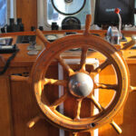
A classic trawler touch, a wooden spoked wheel.
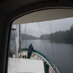
An extra hand on watch as Explorer navigates through some skinny water.
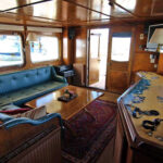
The spacious salon of Explorer.
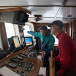
A forward watch position is necessary when navigating through uncharted waters.

The crew in Bottleneck Cove.

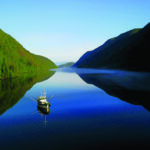
Plenty of trawlers and expedition yachts travel through British Columbia’s Inside Passage in the summer.
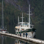
Explorer at the dock.

Outdoor adventure beckons when cruising through the remote landscape of Haida Gwaii.
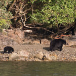
A black bear and her cub along the water’s edge.

For a sense of scale of said bear, she was quite big.

The totem pole is an artform native to the Haida people, these relics still stand watch over these sacred islands.
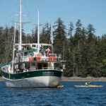
The kayaks come out for some shoreline exploration.
A dinghy is an absolute must for exploring ashore.
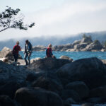
Exploring the rocky coast of Haida Gwaii.
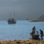
With Explorer safely anchored, the crew heads to shore.
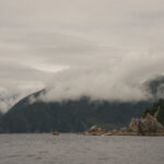
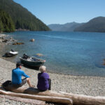
It is easy to take the dramatic landscape for granted in such a beautiful and remote place.

The moon rises just after sunset.
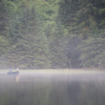
Fishing in protected waters.

The remote waters of Haida Gwaii offer an abundant bounty from the sea.
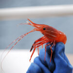
Examining the days catch from a prawn trap.

A classic Northwest experience, the magical beauty of seeing whales in remote waters.
A wider, uninterrupted view of the cover shot from out April 2018 issue.
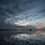
Explorer sits on the hook as the sunsets on a dramatic sky.


