About 70% of the world is covered by water and despite modern technology, GPS navigation, and advanced engineering of vessels, the ocean is still unforgiving. Coastal navigation, with risks of running aground and inconsistent weather and sea patterns, can also be challenging and hazardous. Incomplete data limits our ability to make basic predictions about ocean weather, assess the environmental impact of oil spills, or estimate the impact of changes to ocean acidification. A large portion of our knowledge of the ocean floor is based on lead-line measurements or echo soundings.
For recreational boaters, a healthy marine environment is fundamental. It literally floats our boats. But the ocean also affects those who do not boat: Scientists agree that there’s oxygen from ocean plants in every breath we take. Most of this oxygen comes from phytoplankton that live near the water’s surface and drift with the currents. Like all plants, they use sunlight and carbon dioxide to make food. A byproduct of this photosynthesis is oxygen.
Even with the aid of satellites and autonomous underwater vehicles, we lack fundamental data relating to our oceans. But the more than 300 research vessels worldwide are helping to fill in these gaps. A new addition to this ever-expanding fleet was recently launched on Florida’s west coast, and I was invited aboard for a sea trial.
The Inspiration
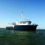
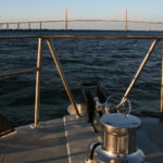
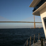
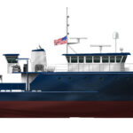
As I crossed the Sunshine Skyway Bridge at 5:45 a.m., I was looking over a predawn Tampa Bay and looking forward to my day aboard the 78-foot R/V W.T. Hogarth, a state-of-the-art marine laboratory designed to support both research and educational voyages.

It was no easy task finding her slip in a labyrinth of alleys, storage buildings, and parking spaces, all part of the University of South Florida (USF) campus in downtown St. Petersburg. As I pulled up to her slip I could see the silhouette of her captain pacing the afterdeck. “I’m glad you’re on time,” Captain David Coy said as I approached the boat.
“There is no man despised more than a late crew,” I replied. Within 45 minutes Hogarth was maneuvered away from her confined dock, and it was still pitch dark.
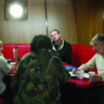
Shortly after clearing the mouth of the harbor we headed directly toward the sunrise. I joined Captain Coy and the first mate, Ryan Healy, at the helm on the dark bridge, illuminated only by the glow of large navigational screens. Below, in the saloon, scientists began to gather for breakfast. Seated around two tables drinking coffee, reading the paper, and talking about the day’s voyage, they eagerly awaited the chef, Patrick Foster, who was about to serve breakfast from the adjacent galley.

Although the Hogarth is a research trawler by design, her motion through the water, her purposeful lines, and her accommodations would seem familiar to those of us who have spent time aboard recreational craft.
This vessel is the result of a concerted effort by the many people who envisioned her, raised funds for her construction, designed her, built her, and now operate her. She is named after Dr. William T. Hogarth, who recently retired after a distinguished 50-year career that included serving as the director of the Florida Institute of Oceanography (FIO), dean for USF’s College of Marine Science, interim regional vice chancellor of USF St. Petersburg, director of the National Marine Fisheries Service, and chair of the International Whaling Commission. Hogarth also led the scientific response to the 2010 Deepwater Horizon oil spill.

It was on his watch that FIO petitioned the State of Florida to provide $6 million to fund the construction of the new vessel. The initial proposal was rejected, so Dr. Hogarth turned to the 22 academic members and the 11 Florida marine research members to contribute to the project. The final funding was a joint effort by the state, the City of St. Petersburg, and FIO membership.
The committee formed to oversee the project consisted of representatives of the crew, including Captain Coy, educators, scientists, and representatives of FIO membership. They met for 18 months and developed a comprehensive program for the vessel and its objectives. The design was awarded to Boksa Marine Design in Lithia, Florida, and the construction to Duckworth Steel Boats in Tarpon Springs, Florida. Hogarth was launched in May 2017 and then spent several months getting her advanced scientific equipment installed in between sea trial runs.
The Boat

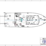
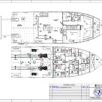
The hull specifications consist of a combination of plate thicknesses. “The side plates from the chine to bulwark cap are ¼-inch and the bottom plates from the chine to keel are 5/16-inch,” said Jeff Keunning of Boksa Marine Design. “There are several inserts of ½-inch at the bilge keels, the propeller nozzle, and the rudder area. Also there is a 5/16-inch cutwater from the stem back 12 inches. This runs parallel to the curve of the bow from the cap rail to the chine.” When I asked Jeff about the bulbous bow configuration, he said, “I hesitate to comment as there are significant differences in opinion on the effectiveness and advantages of the bulb bow.” Forward of the 400-square-foot stern work platform there are two cranes, towing equipment, and work boats, as well as a central entrance to the lab area with a dry lab to port and a wet lab to starboard.


A passageway leads forward to the saloon and galley. Stairwells to starboard lead below to 10-person sleeping accommodations, as well as access to the engine room. As you would imagine, the fit and finish of these spaces are appropriate to the boat’s purpose, prioritizing function over style. Her guest accommodations consist of bunks in shared cabins. Because she is a government asset, entrance to the engine room is limited to the ship’s crew. However, I was able to peer through the explosion-proof door and glass to see Hogarth’s two immense Caterpillar diesels at work. Her saloon and galley occupy the forward end of the hull, and she is finished in the style of a working ship. There’s a galley, a beverage bar, and two large fixed tables with enough seating for the crew and scientists. About this time in my tour, breakfast was ready. A choice of bacon and eggs, omelets, or pancakes were made to order. This was certainly the best (and possibly the only) breakfast I’ve been served while underway on a boat test.
A third stairwell leads up to the command bridge, which is almost full beam in width. As you might expect on a vessel of this type, the instrumentation and controls were overwhelming and state-of-the-art. A look at the specifications gives you an idea of what it takes to operate such a complex vessel. There is an entire control center located to starboard that is reserved only for the dynamic positioning system. Its final installation had not yet been completed, though, so I did not get to see it in operation.

By midmorning we had anchored off the point of Fort De Soto. The RIB was launched with one of the cranes and I was taken to shore. The water was too rough to land at the dock so we ran up on the sand nearby. Hogarth was picking up another group of oceanography students to work on a fish population study. I rode back to the campus to make my appointment with Dr. Philip Kramer, the current director of FIO.
The Science
Dr. Kramer explained that FIO is an independent organization with a staff of 30. In addition to W.T. Hogarth, they operate three other research vessels ranging from 25 feet to 115 feet. They also have a research lab located on Layton Key.

“We are basically a facilitator providing assets that are too expensive for individual organizations to own, operate, and maintain,” he said. “We also are coordinators of information that is produced by our member organizations, and we provide an enhanced educational experience to oceanographic students above and beyond the classroom.” The institute provides important research for fisheries, bottom mapping, and coral habitats, and it has been very involved in monitoring the recovery following the Deepwater Horizon oil spill. Because the Gulf of Mexico is fairly contained, this spill represented a unique opportunity to measure the short- and long-term environmental impacts of such a disaster.
In addition, detailed mapping of the Gulf floor is underway using dual-head swath mapping instruments. The Florida shelf extends 200 miles from the west coast and 60 miles from the east coast. The ultimate goal is to provide mariners with far more detailed and accurate information of the ocean floor below our vessels. The collection of this oceanographic data is a coordinated effort that includes not only the research vessels but also a multifaceted network of hardware and software. The NOAA diagram shown above illustrates the complexity of the process.

Hogarth’s assignments are based primarily on research grants initiated by governmental agencies, independent research organizations, and educational institutions. These assignments may take her out on the sea for days or weeks at a time. After completing sea trials, Hogarth will tour the state, visiting all of the FIO member organizations to introduce them to the vessel and her capabilities. She will begin actual research trips in the summer of 2018. My day aboard this unique vessel and my visits with FIO personnel gave me a much better understanding of what is involved in the exploration and maintenance of our marine environment.