
App developers have been working to deliver a chartplotter experience on tablets ever since Apple introduced the iPad in January 2010. It’s still debatable whether tablets are suitable as full replacements for installed marine navigation equipment, but some developments in the field make that debate livelier.
For starters, today’s navigation apps are impressively robust with complete feature sets. In many cases, an internet connection and easy update mechanisms can deliver more or different functionality than traditional installed navigation electronics. However, heat, weather resistance and durability remain the Achilles’ heel of tablet-based navigation systems.
In contrast to an installed navigation system, tablets give boaters options at their fingertips. Want to use Navionics charts? Download the Navionics Boating HD app and access the most recent charts for $49 a year. Need the U.S. Army Corps of Engineers survey data for the Intracoastal Waterway? Aqua Map offers that plus route-planning tools, weather and more for as little as $25 per year. Options including Argo, Coastal Explorer, TimeZero, iNavX, Orca, Savvy Navvy, SEAiq, Seapilot, Wavve and others offer myriad features, social integration, crowdsourced data and automatic routing options.
With the cost of apps typically around or below $100, many boaters choose several apps and maintain subscriptions to them. In my own cruising, I found that I preferred one app for open-water passages and another on rivers and the ICW. Once I made it to the Bahamas, I wanted Explorer Charts for their high-quality coverage of the archipelago.
Tablet navigation’s roles
Tablets can be used in several ways aboard a boat. First, they can be used exclusively as planning tools, typically with an app provided by the manufacturer of the navigation package aboard the boat. Second, they can be used to supplement the onboard electronics. In this role, they provide additional sources of charts—often from additional publishers—access to crowdsourced data, and redundancy against power or equipment failures. Last, tablets can be used to replace navigation electronics in their entirety.
When it comes to planning, all of the major chartplotter manufacturers offer companion apps. These apps allow boaters to plan trips and manage their plotters. Several manufacturers utilize their apps to update firmware and charts. Additionally, almost all of the companion apps offer the ability to mirror the display of onboard chartplotters and control them. However, the majority of these applications aren’t designed to be used for navigation by themselves.

For boat owners with serviceable electronics on their boat, a tablet may also provide an alternative source of charts, an updated user interface, access to crowdsourced data, or access to specialized data sources. One advantage of tablet navigation apps is the ease with which a boater can switch between them.
Some boaters rely exclusively on tablets to navigate. In environments with simple navigation needs, this can be an appropriate and cost-effective solution. However, I regularly hear the case made for exclusive reliance on tablets in more demanding circumstances. Sole reliance on tablets may work for experienced boaters with a good command of the potential pitfalls and the knowledge to see themselves through challenges, but general-purpose tablets pressed into service as the only navigation device on a cruising boat can also be a source of frustration and trouble.
Perhaps the most common comparison a boater will make comes when comparing a tablet to new, installed electronics. They consider a 9-inch chartplotter and find a price tag of $1,200 to $1,500. In comparison, perhaps they already have a tablet or see that they can buy a basic one for little more than $100. Even after adding multiple apps, the startup costs for tablet navigation compare favorably to installed navigation electronics.
Built for the environment
However, it’s important to talk about heat dissipation and weather resistance for tablets. These devices are thin and light. Most are not water-resistant. Current iPads don’t have an IP rating at all.
This means that on a hot day, a tablet in direct sunlight is likely to overheat and shut down. Additionally, many tablets simply aren’t bright enough to be seen in direct sunlight. When a tablet gets warm, one of the first things it will do is dim the backlight to try and cool itself off a bit. Paradoxically, when light levels are at their highest, and hence heat is too, the tablet will begin to dim.
If the weather becomes inclement, the tablet will need to be protected. There are options for weather-resistant enclosures, but those typically come at the expense of an ability to reject heat, thus exacerbating the cooling issue. Cooling fans are also available to attach to the rear of the tablet.
Even after these issues are addressed, the tablet needs to be physically secured and charged. Mounting options range from inexpensive to rivaling the cost of the tablet itself. Charging a tablet sounds trivial, but tablets running at maximum brightness while GPS is active can consume a lot of power, so larger chargers are needed.
Tablets can be connected to onboard instruments and equipment using converters from NMEA 2000 to Wi-Fi. These devices make data from a boat’s NMEA 2000 network available to a tablet or phone via Wi-Fi. That data enables sharing boats’ GPS, depth, AIS, weather data and more. Plus, several applications make control of autopilots possible via gateways from Wi-Fi to NMEA 2000.
By the time a boater purchases cases, cooling fans, power supplies, mounts and gateways, that initially favorable cost comparison may not look quite the same. Plus, all these components take what looked like a simple solution and add significant complexity. And, even a tablet with a gateway doesn’t make radar or graphical sonar systems available on the tablet.
A hybrid solution
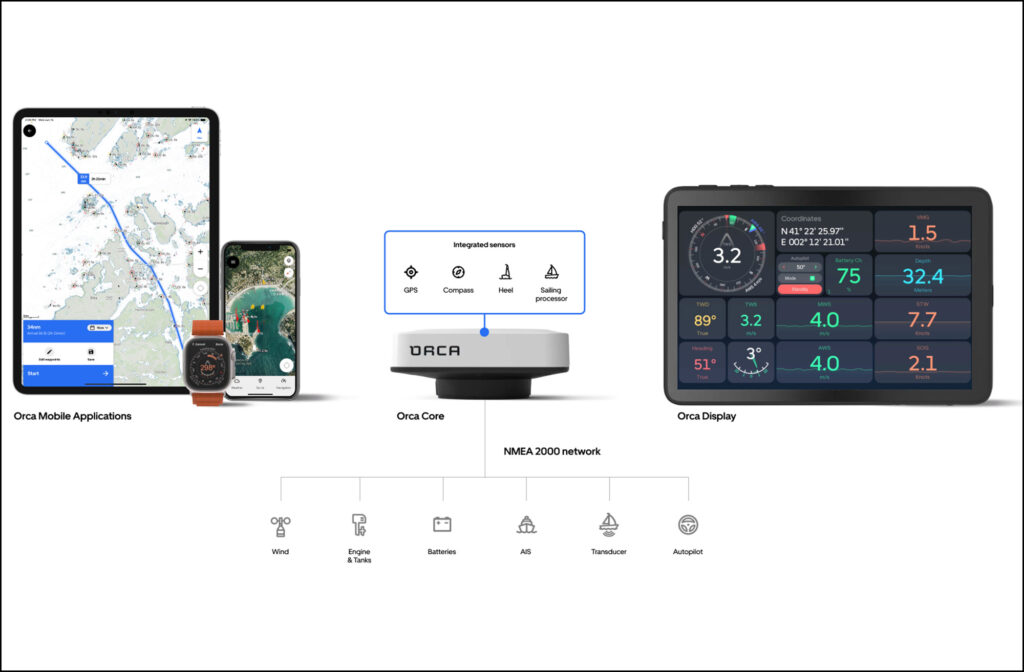
Orca, a Norwegian navigation technology startup, offers a hybrid solution. Its system consists of an iOS and Android app, Core sensor and integration unit, and Display 2 marinized tablet. Orca users can run the app on their own tablet or on Orca’s. Also, they can use the tablet’s built-in GPS or use the Core’s high-accuracy positioning sensor along with its nine-axis inertial motion unit, compass, NMEA 2000 interface and Ethernet interface.
The NMEA 2000 interface in the Core lets boaters display location, weather, AIS and engine-gauge information. Additionally, the NMEA 2000 interface allows full control of compatible autopilots from all major manufacturers. The Ethernet interface can connect to a Raymarine Quantum 1 or 2 radome and display the radar’s output on the app.
If a boater uses Orca’s core and their own tablet, they will get the full functionality but still have to contend with the heat and weather concerns of their tablet. Orca’s Display 2 is weather- and heat-resistant. It is intentionally larger and heavier with extensive weather sealing and the ability to reject the direct heat of sunshine on its display.
Orca also offers a robust charging mount that physically holds the tablet in place and provides ample power to ensure the battery remains fully charged regardless of what loads are placed on the display.
What it all means
Tablets aren’t a fit for every boater, and they don’t solve every need. I’ve recently started seeing custom dashboards built around marinized tablets as the primary navigation and vessel control system, but I’m still not aware of a system that addresses needs for advanced sonar systems.
Additionally, as boatbuilders offer more highly integrated boats with control of the vessel’s climate, switching, engines and more from the helm, tablets may not meet these needs. However, it may be interesting to see what a creative boatbuilder and app developer can do together to offer holistic control from anywhere on or off the boat.