
For long open-water passages, a sailor needs a sea-worthy vessel, capable crew and captain, safety measures in place, good luck and so on. But on these journeys, much of it comes down to one critical factor—weather. And that means being prepared, watching, waiting, and then scooting when the time comes. In 2011, we spent Thanksgiving weekend in Apalachicola, Florida soaking up the town’s history and charm, all while waiting for a favorable weather window through which we’d cross a corner of the Gulf of Mexico from Florida’s Panhandle to the west coast.
After conducting our own weather research, listening to other boaters also waiting, asking local sailors and seeking the advice of weather experts, about a dozen of us agreed we’d have a weather window during which we could cross the big water. We watched real-time data on buoys, checked the National Weather Service forecasts, read reports from a Looper favorite named Tom Conrad who provides sage advice to boaters for this crossing, listened to advice from a local dockmaster and weather guru in Carabelle, Florida named Buddy and also consulted our favorite professional weather router Chris Parker. All agreed it was doable for bigger boats but that it wouldn’t be entirely comfortable. That’s boating we reckoned.
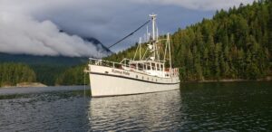
Looking at the charts and our projected course, we estimated the trip aboard our Krogen 48 trawler, Muddy Waters, would be just shy of 200nm from Apalachicola to St. Petersburg, dock to dock, and we would average 7.5–8 knots. We set off from Scipio Creek at 0800 on a cool, grey Wednesday morning, a week after Thanksgiving. Working our way east between the mainland and St. George Island and passing a dozen boats harvesting oysters, we crossed into the Gulf of Mexico through the East Pass inlet just shy of Dog Island. We were greeted with light winds—not bad weather at all and in line with the forecast.
MOVING ALONG
For the next seven or eight hours we moved east and southeast, plotting new target waypoints on the hour and making a gentle turn to the south. We watched the wind and waves, maintaining our course based on crew comfort, overall distance, and the weather forecast. In these parts this is called the rim route, as opposed to the rhumb line that’s a run straight across. We generally followed the contour of the big bend of Florida’s coast, looking to stay about 20nm or so offshore. Since the water was relatively calm, with a slow rolling following sea on our stern and then starboard stern quarter, my wife, Jennifer, and I decided to use our off-watch time to sleep, something we knew would help us stay alert while driving at night. Our 13-year-old son, Keenan, also took turns at the helm, and our rule was always to have at least two people in the pilothouse, both awake of course!
By late afternoon we were turned almost due south when we began to spot multiple strings of crab trap buoys. In our experience, traps seem to be set most often on the shelf edges, where water depths change most dramatically. That said, it’s relatively shallow dozens of miles from shore in the Gulf of Mexico and you might see a trap marker just about anywhere. You don’t want one wrapped in your prop because in addition to interfering with someone’s livelihood, you might disable your boat. Other than getting lucky and having the trap line slide off or putting your engine in reverse and unraveling the wrap, there’s not much to do except get in the water and cut the line. We didn’t fancy doing that way out there, though we carried wet suits, mask, and knives partly for that purpose.
Since night was approaching and we wouldn’t be able to see the traps to dodge them, we decided to move farther offshore, choosing a line about 30nm out from land. Because the weather had been calm earlier and Jennifer and I were well rested, we decided to relieve Keenan of his nighttime watch duties, and he offered to rise early and take a turn at the helm in the wee hours just before sunrise. Keenan and our 12-year-old daughter, Daria, turned in around 2130, each with a book and with extra blankets for the cold.
CHOPPY SEAS
As expected, around 2300 the wind picked up. The waves were also increasing in height and intensity. We continued to have a west-northwest swell which then combined with a vicious chop offshore generated by strong winds as a high pressure system was moving over the Florida peninsula and funneling cool air offshore. Our window was closing sooner than expected.
From Muddy Waters’ movements, we knew we were in washing machine seas. Like an industrial washing machine—maybe the type they use after an NFL game between the hated New York Jets and our beloved Miami Dolphins. Because the waves were coming from astern, albeit from two directions, we weren’t pounding, slapping, or even getting much spray on the pilothouse glass. But, we were rocking and rolling like a Chuck Berry tune. Our hydraulically operated stabilizer fins were working overtime to bring us back to a level plane. Every minute or so it seemed a wave would wallop us more violently than the others. We couldn’t see the big ones coming, but we started to time them at about every 60 or 90 seconds.
Before departing, we had triple checked that everything was secure onboard, including our 14-foot dinghy, two stand-up paddle boards and everything else above and below decks. Other than a few items shifting around in drawers and plates and glasses clanking in the galley cabinets, there wasn’t much noise other than thettttttssssshhhhhh of the water rushing past the hull. I imagine these masterfully built Krogen trawlers are designed to flex certain tiny amounts given the architecture and materials, but it was amazing to us how solid everything felt through the rough weather and agitated sea and boat movements. Still, we imagined ourselves like a featherweight ping pong ball in an air mix lottery machine.
We also found ourselves in the wheelhouse bundled up with wool hats, gloves, sweaters and jackets too. The chilly air kept us alert through the night. Jennifer was tough as nails, as always, and took solid stretches at the helm while I rested. Because we weren’t running a straight course and had to plot our position regularly as we adjusted course based on weather and those pesky crab pots, we were busy looking at our paper charts and chartplotter. At one point, while focusing on our charts for a little too long in heavy seas, I felt a deep gurgle in my belly and promptly offered up the, um, recycled contents of a can of ginger ale to King Neptune!
FELLOW CRUISERS
Late in the evening we also saw a few blips on the radar ahead of Muddy Waters. We knew other trawlers were traveling at the same time—coordinated masterfully through the efforts of Spirit of Whitby—and suspected we were near a few fellow cruisers on the Great Loop like us. We listened on the radio and heard three boats conversing on and off and eventually recognized the names Kismet, Something Special, and Lady in Red. We said hello across the airwaves and noted we were a few miles behind the group. We all had trouble getting strong signatures on our radar displays given the bouncy seas, but we eventually were close enough to see solid radar pictures of the vessels and get a stronger radio connection.
We all noted that with the quasi-following seas, we were making faster time than originally expected and realized we’d need to slow down so we could avoid arriving at the Clearwater Pass Inlet in the dark. We also heard discussion of one boat possibly moving 10 or 15 miles closer to shore because of the vicious seas. Another boat seemed to be moving farther offshore because of the crab pot risks. By then, however, we were having trouble hearing anything clearly on the radio, so we weren’t sure if it was the same three boats having this discussion or some other boats. We eventually lost track of the three boats on the radar.
After a few more hours, we saw three boats on the radar again, this time astern of us a few miles. We assumed we’d passed the three boats we’d first seen and were now ahead of them. I heard distant discussion on the radio from Kismet and Something Special about temporarily proceeding past the Clearwater inlet to run a north-south course in the heavy seas until sunlight. Mistakenly assuming they were the vessels astern of us, I hailed them and asked if they were near the inlet or, like us, still 20 miles from it. Since I assumed we were just ahead of them, and I gathered from our charts that we were still far from the inlet, I was concerned they weren’t in the position they thought or, much more likely, we weren’t in the position we thought.
I was wrong of course, as they knew exactly where they were, and they confirmed they were indeed almost abeam of the inlet. Hmmm. It turns out the boats astern of us were from a different group. I was watching the boats on the radar behind us but listening to the boats on the radio ahead of us. Eureka! Given our tired and woozy state, Jennifer and I celebrated solving this little positional puzzle that in our minds was nothing short of a monumental breakthrough in the geographical earth sciences.
One of the vessels was Wonderland, another Gina Lee, and the third we never identified. Wonderland and Gina Lee, both of whom we’d met in Panama City, had run the rhumb line from East Pass inlet, departing a few hours after us but driving a more direct route and arriving at the same time. They too had a rough ride, as they were even farther offshore much of the way. By this point we were about 15 miles from the Clearwater inlet and sunrise was fast approaching.
We learned from Wonderland that the captain aboard Gina Lee, hired for the passage, was highly experienced in these waters, and we asked if we could follow them through the shoals and crab pots and into the inlet. With the wind still honking, we adjusted course to port and headed toward the inlet with a rising sun in our eyes. We dodged a few crab traps and then…near silence. No whoooooosh of the waves screaming past the hull, no sea mountains to climb. We were through the inlet and in calm waters. Relief. Just then our kids woke from their deep-sea slumbers, noting only that the ride was a little bumpy but not too bad. Not. Too. Bad. Did I hear that right? To the brig with the both of them!
WHAT THE WAVE?
Once we arrived in St. Petersburg later that morning, I wrote Chris Parker, whose reports we rely on regularly in the Bahamas, and asked if he could help us estimate wave heights during our Gulf crossing. Here’s what he wrote:
“The buoy 28.5N/84.5W shows wind 16 knots, gusting 22 knots, during this period, with seas at 4 feet in 8 second intervals. Estimating sea height is difficult, as we on small boats tend to remember the largest seas, and say that was the height of the seas. Significant sea height (the numerical average of the 33% of largest waves) was probably 5 feet (4 feet at the buoy, maybe 5 feet where you were with wind a bit stronger). Based on your wind, which was probably 20 knot/gusting to 25 knots, seas should have been mostly 5 feet, possibly 5–6 feet. Well, offshore, a 20-knot/gusting 25-knot wind might eventually develop 7 feet seas.
Some seas are much higher than the “significant seas”…maybe one wave every 10-30 minutes can be 2x as large. Adding to the complexity is the NW-N swell, which may have phased with wind chop and caused mor numerous waves of 2x the significant sea…so you may have seen one wave every couple minutes in the 8-foot, 10-foot, 12-foot range. But, again, the significant sea height was probably about 5 feet, maybe 5–6 feet. You should expect an occasional wave 2x that high. You may have seen one of these larger waves every couple minutes (10x more often than normal) because of the swell from a different direction.”
With all the darkness and movement out in the blue yonder aboard Muddy Waters, we would have easily believed Chris if he’d written us and said sea serpents and monsters were battling beneath the surface and creating roll and tumble seas for our humble little craft that ventured too far from shore!
Though we’ve been in memorably rough seas (for us anyway) a few times—on the Exuma Sound, Lake Michigan, and offshore of New Jersey and Maine coast—the overall conditions crossing Florida’s Big Bend were as taxing on us as any we experienced on the Great Loop, in the Bahamas, or up and down the East Coast from Florida to New England. We were happiest of all that day to see reports from the other boats that had also arrived safely—shaken, not stirred—on Florida’s west coast. Each season, cruisers wait patiently for good weather to cross that patch of open water in the Gulf of Mexico. Wishing them wonderfully wide weather windows.
You can follow the Samways’ travels aboard Muddy Waters at www.samwayadventure.com.