When I first heard about the Automatic Identification System, I rolled my eyes and made some curmudgeonly comment about yet another gimmick to sell more marine electronics.
I can admit it now. I was wrong.
Really wrong.
AIS has been a game changer for boating safety. While radar can detect vessels that don’t have AIS transponders (or don’t have them turned on) as well as other hazards, there’s nothing quite like AIS for providing critical information to avoid collisions at sea. AIS can show the location, course and speed of vessels even when landmasses or other conditions obscure them from radar.
And because AIS data includes a vessel’s type, size and name, it’s easier to identify specific vessels and call them by name to arrange safe passage. Some integrated systems will even allow you to initiate Digital Selective Calling automatically, by touching or clicking on an AIS target on a chartplotter.
Beyond all these safety enhancements, AIS has also spawned an entirely new industry in collecting, aggregating, analyzing and distributing data via the internet. Commercial shipping companies, governments and ports use this AIS data for a variety of tracking, planning and security purposes, as well as in search-and-rescue applications.
Recreational users usually have simpler needs, but it’s still valuable to be able to locate your friends or family on their boat, whether just around the corner in the next bay or on the other side of the globe. With the widespread adoption of broadband internet connections like Starlink, some marine electronics manufacturers are even integrating internet AIS data with onboard AIS receiver information, displaying both types of targets on the same display. With this capability, you can see vessels that are out of the range of your AIS transponder.
But this capability has also created some potentially dangerous misunderstandings about the reliability and timeliness of AIS data available on the internet. Worse yet, some boaters are relying on internet apps or websites for AIS data instead of installing an onboard AIS receiver or transponder, thinking that they’re getting the same information.
Now, more than ever, it’s critical to understand the value and limitations of AIS data available via the internet.
The Origin Points
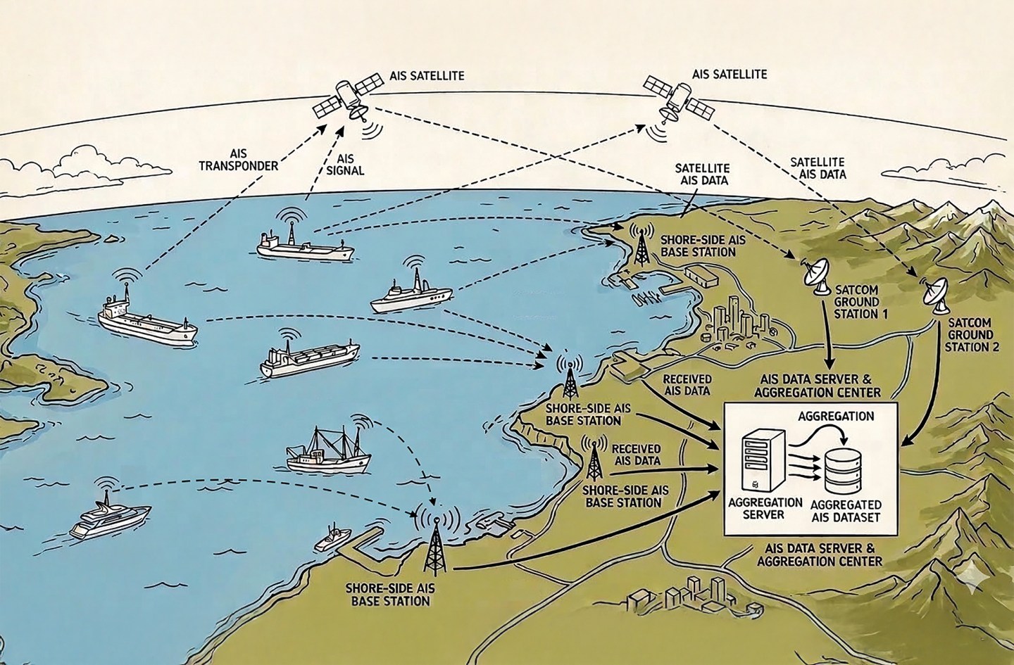
Onboard AIS transponders broadcast their position information in digitally encoded signals on two reserved VHF radio channels. Other nearby vessels with AIS receivers or transponders directly receive the transmissions. AIS networks also pick up these signals by stationing receivers in homes or businesses along the shore. The stations forward the AIS data to a central server computer that aggregates data from dozens, if not hundreds, of AIS-receiving stations.
This process creates a single worldwide database of AIS information. Apps and websites get information from this central database to create a map view, similar to what you would see on your chartplotter.
Most shoreside receiving stations have volunteer hosts who install a receiver and connect it to the internet in exchange for premium access to the network’s data or services. I host one of these AIS stations at my home. It’s two small boxes that I mounted in the attic above my garage, and a VHF antenna mounted on the roof above the garage.
Shoreside stations, however, have significant range limitations. Like VHF voice radio traffic, AIS signals are limited to line of sight, which means they can’t reach farther than the horizon. Class A transponders typically found on commercial vessels and larger yachts broadcast using 12.5 watts of power, while Class B transponders broadcast at 5 watts, and some older ones at 2 watts.
In practice, this means that Class A transponders typically have a range of 10 to 30 nautical miles, while Class B transponders have a range closer to 5 to 10 nm.
If the AIS network relies solely on shoreside receiving stations, then once a ship or yacht gets more than about 30 miles from the nearest shoreside station for a particular network, that vessel will “disappear” from the network’s data. Some of the larger AIS networks, like Marine Traffic, overcome this range limitation by putting AIS receivers on satellites in low earth orbit. The receivers are still fundamentally the same as the ground stations, and they pick up the same VHF radio frequencies using the same onboard transponder equipment. However, they have much greater range because they overcome the line-of-sight issue.
Of course, launching and maintaining AIS receivers on satellites is much more expensive than the low-cost receivers that volunteers host in homes or businesses. As a result, many networks limit satellite-data access to premium customers. You may see vessels appear in the middle of the ocean on some of these apps or websites, but their names and other information is obscured, since it requires a paid subscription to access.
Recently, with the proliferation of high-bandwidth, full-time internet connections on board, a third AIS data source is becoming more common. These are roving AIS stations aboard ships or yachts.
Since most larger vessels these days have at least an AIS receiver, and many have full-time internet connections such as Starlink, it’s now possible for vessels to become an AIS station for one or more networks. All that’s required is an interface between the AIS transponder and the internet.
On board my Selene trawler, that interface is a tiny Raspberry Pi computer that connects to the NMEA 2000 bus and to the internet via Starlink. It can forward the AIS targets my transponder receives to the AIS network. We actually forward our AIS data to two different networks on board.
These roving AIS stations can significantly improve the coverage for a network, especially when we cruise in remote areas. In Alaska, for instance, shoreside stations are few and far between, and coverage for even the largest of the networks is sparse without using satellite data.
Another advantage is that you automatically forward your own position to the same networks as part of the process. Your vessel never disappears from the AIS networks that you forward data to, as long as you have an internet connection. Some systems will even buffer our position reports and other vessels’ information if we lose our internet connection for a period, and then catch up when the connection is restored.
Delayed Reporting
Because all AIS transponders share the same two VHF radio channels, it could seem as if everyone in an area is trying to talk at the same time. The result would be total chaos. AIS solves this problem by using a protocol called Time Division Multiple Access.
Essentially, each of the AIS transponders in a given area is only allowed to transmit in its assigned time slot. Older Class B transponders use a simplified variation of this protocol; they wait and listen to see if any other transponder is transmitting, and then they try to transmit.
As a result, AIS transponders do not broadcast continuously. They broadcast in small bursts, with the interval between bursts dependent on the vessel’s speed and the nature of the data. A vessel moving less than 3 knots or at anchor only broadcasts its position, speed and course every three minutes. Static data, such as the name of the vessel and its length, are only broadcast every six minutes. At higher speeds, Class A transponders broadcast position course and speed updates at two- and 10-second intervals, while Class B transponders do so between five and 30 seconds.
It’s easy to see how a vessel could move out of the range of a shoreside or roving AIS station between its transmissions. It may move into the range of another station later, but in the meantime, the network has essentially lost track of this vessel.
How long should the app or website continue to display the last received position? There is no standard method for handling these situations. Various AIS networks and displays handle it differently.
On most apps and websites, you can touch or click on a target to get more details, including the amount of time since the last position update was received. Some apps will let you specify how long you want a target to remain on the display after the last update is received. Others change the color or shape of the icon as the position ages. Some will dead-reckon and automatically advance the target along the last known course and speed until the next update is received.
The key to interpreting this AIS data is understanding how the network and display system you are using handles these stale position reports. Pay attention to the details that show how long it’s been since a position update, and treat targets that haven’t been updated for many minutes as suspect.
Data Latency
Another factor to consider is how long it takes from the time a network’s station receives a transponder signal until that position update appears on the app or website.
There are layers here. First, how long does it take to get the position update from the receiving station through all the processes required to update the central database? For most shoreside and roving AIS stations, this latency is usually a few seconds or less. However, for satellite-hosted AIS stations, the latency can be considerably longer because in some cases, the satellite can’t get the received data back to earth until it passes over a specific area where a ground station can receive the data. There is also considerably more processing required to prepare the data received from satellites, and the satellite may have received position reports from hundreds of vessels at sea in some areas. As a result, latency of even a few hours is not uncommon for satellite data.
The other factor is how often the app or website refreshes its display from the central database. This amount of time can vary significantly among systems. Some websites and apps attempt to reproduce a chartplotter display with near-real-time updates. Others simply show the most recent position report and may not update until you refresh the browser window.
The Bottom line
Internet AIS networks have opened a new view of marine traffic. However, like all powerful tools, this one can be misused with potentially disastrous consequences. The key is to understand the limitations of the data you see on these networks.
You can avoid many of the pitfalls just by touching or clicking on a target and looking in the detail window for the last update or last received value. The longer the time since the last update, the more suspect the position report is.
Never rely solely on an internet AIS display for onboard collision avoidance. Internet AIS data, whether on an app or integrated on your chartplotter, is not a substitute for an onboard transponder, a properly tuned radar and, ultimately, your best collision-avoidance tools: eyes and ears.
This article originally appeared in the September 2026 issue of Passagemaker magazine.