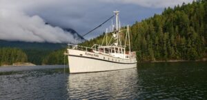


M/Y Egret, our little white fiberglass ship (a Nordhavn 46 flybridge), started her southern winter cruise in Nelson, on New Zealand’s South Island, in late April of last year. Our intent was to cruise down the east coast of South Island after traveling through the protected Marlborough and Queen Charlotte Sounds at the top of the island.
Departing South Island, we would cross Foveaux Strait to Stewart Island, which lies south of South Island. It would be a rock-and-roll ride deep into the “roaring 40s,” a term that refers to the boisterous winds in this latitude region. Egret has no schedule and will move only in acceptable weather. We learned during our 15 months cruising in Argentina and Chile that even in areas of extreme weather, there are good days-and those days are when we move. The balance of the time, we snuggle in bombproof anchorages, and together we see how Egret‘s plans will unfold.
We delayed our departure from Nelson to attend the ANZAC (Australian and New Zealand Army Corps) Day Parade, which took place at dawn. (ANZAC Day is the equivalent of our Memorial Day.) Then, after inevitable this ‘n’ thats, we got under way. Joining us for the first part of the trip was Dick Anderson, a local resident and longdistance powerboat enthusiast. It was time to go, even if the weather wasn’t optimal: we needed to catch the tide five hours away at French Pass before the night’s anchorage.
We punched through tight, 6-foot head seas until we reached deeper water. It didn’t matter to Egret; she was doing what she loves to do, shaking a bit of salt and leaving on another mini-adventure. French Pass turned out to be a nonevent, but if we had waited another hour, things would have been very different.
After running through Marlborough Sounds, we entered Queen Charlotte Sound to spend three days waiting for a weather window for our first overnighter to Akaroa, on the south side of Banks Peninsula. Departing in an ink-black predawn, it was a nervous couple of hours navigating by radar and chart plotter through the narrow, rushing-tide channel to the entrance of Cook Strait. Needless to say, when the sky lightened in the northeast, it was a welcome sight. The overnight part of the trip to Akaroa was a calm affair.
LET’S TALK ABOUT THE WEATHER
Before we move on, we should explain a few things about South Island weather. In the early part of our New Zealand cruise, northerly quadrant winds were the issue. However, starting mid-island, westerly quadrant and southerlies were the predominant winds, arriving directly from Antarctica. At these latitudes, lows march around the Southern Ocean in an uninterrupted chain. In southern New Zealand, the lows tend to move from southwest to northeast. This time of year the weather is changeable, but things calm down during the latter part of the winter.
Akaroa is a beautiful little village that was first settled by the French in their attempt to colonize New Zealand. Although it didn’t work out for the French contingent, quaint older homes near the harbor retain their French heritage. Unfortunately, our weather window demanded that we move on after only a half-day’s visit. Loaded with French baguettes, we departed, cruising on another easy overnighter to Port Chalmers, with albatrosses, petrels, and even an orca whale for entertainment along the way. Port Chalmers is a small town upstream of the city of Dunedin. Egret, anchored in Careys Bay, just east of the commercial port and in front of the home of a fellow cruiser we had moored next to in Nelson.
Before arriving in Port Chalmers, we’d had a bit of excitement. The autopilot had given up, so we’d had to hand-steer the last 40 or so miles. Once docked, we made a quick Iridium satphone call to the folks at Accu-Steer, makers of Egret‘s autopilot pump. A double-check of their diagnosis proved them right, and shortly our autopilot was up and running.
There is an important lesson here: We carry a complete spare pump, spare motor, and spare brushes. In the end we needed no parts, but had we been in a Third World country and needed parts, it could have been a nightmare. Overall, the problem turned out to be a good experience, teaching us to hand-steer a straight course by using a separate laptop with navigation software zoomed down and steering the course line. At the time, we had 30 knots of wind on the stern. It was no problem once we got the hang of it, but the breaking waves at the river entrance did add some additional excitement.
While in Port Chalmers, we explored the town and spent time in nearby Dunedin. We also rented a car for four days and visited Te Anau, on the west coast, and the Department of Conservation office for a second time. Here, we were given a marine mammal sighting guide to complete as we ran into the listed species.
Nineteen days after arriving in Port Chalmers, we had good enough weather to make the 24-hour run to Stewart Island. We drove into 10-foot head seas and winds to 25 knots, but the wave spacing was such that it wasn’t that bad. The final third of the trip was spent with slight following seas and little wind. We arrived at Halfmoon Bay, off of Oban, Stewart Island, after 24 hours-exactly as planned.
With 390 full-time residents, Oban is the only settlement on Stewart Island. We spent one rolly night anchored in Halfmoon Bay. The next day we cruised around the corner to Paterson Inlet, a large, multi-fingered bay, and anchored in Golden Bay, just over the hill from Oban.
Having no schedule, our routine was to anchor in different spots and take daily hikes, exploring the Department of Conservation (DOC) trails. Some Aussie powerboaters loaned us books about the history of Stewart Island. We also collected brochures at the i-SITE-part of New Zealand’s official visitor-information network-and at the DOC in Oban, and we bought Rakiura by Rob Brown, an informative coffee-table book with stunning photography. (“Rakiura” is the Maori word for “Stewart Island.”) With all these sources of information, we had a good overview of the island and where we wanted to go. Our favorite anchorages in Paterson Inlet were Little Glory Bay, Kaipipi Bay, Kidney Fern Arm, and Golden Bay. Additionally, we day anchored in Ulva Island’s Sydney Cove and at Millar’s Beach.
The majority of early European settlements were near Oban, particularly around the protection of Paterson Inlet. Little remains of these settlements; second-growth forests have reclaimed the land. One interesting bit of history is the Norwegian whaling station near Millar’s Beach. This settlement was established to maintain whale-chasing ships working the Ross Sea. What remains are the building foundations, the old steam boiler that ran the railway, and ice-damaged propellers lying on the beach.
Beautiful DOC trails surround much of Paterson Inlet, taking you through regenerative second-growth forests with their fern carpets. Many follow old logging trails from the 1800s. In difficult-to-log areas, one finds first-growth rimu and rata trees still standing after many hundreds of years. In one bayside wash, Mary discovered a leg bone from a moa, an extinct flightless bird similar to today’s ostrich. The bone had been cut by early Maori to make fishhooks. After confirming what we thought she had found, we donated the bone to the Rakiura Museum in Oban.
PORT PEGASUS: A WINGED JOURNEY
Next, we set off around the corner and down the east coast of Stewart Island to Port Adventure. After a short run of 18 nautical miles, Egret anchored in Abraham’s Bosom. Here, we spent days exploring the nearby beaches in our dinghy. Our favorite activity was our early-morning walks at low tide, when we would see what the tide had brought in. Along one beach there’s graffiti carved into the rock from the 1800s to the present. In another bay are three beaches, each with a different type of sand: powdery white, heavier tan, and coarse brown.
After returning briefly to Paterson Inlet and Oban to deal with a minor medical issue, Egret headed for the crown jewel of Stewart Island cruising: Port Pegasus. Port Pegasus is a two-armed bay separated by three barrier islands. Landward of the islands is a narrow channel connecting the North Arm with the South Arm. We made an overnight stop in Lord’s River, but with weather on its way, we left early the next morning for the short hop to Port Pegasus, with no further exploring.
As you move south on Stewart Island, the topography and foliage change dramatically. The northeastern section, around Oban and Paterson Inlet, has gentle, rolling hills and is heavily forested. To the west are barrier mountains and a drier climate. The changes are even more dramatic as you leave the North Arm of Port Pegasus and travel but a few nautical miles to South Arm. Here, the west coast mountains give way to low hills, allowing relentless western-quadrant winds to scour the landscape, and the beautiful tall trees of the north are replaced by tough manuka trees. As you move closer to the west coast, where there is even less protection from the wind, the manuka trees give way to stunted-growth manuka scrub. The southern section of the east coast of South Arm is the exception, with nearly full-growth trees and magnificent fern-paved forest floors. As in all of nature, everything has its own beauty, including the scrub. Even though the southern part of Stewart Island is but 47 degrees south, it reminded us of parts of the Chilean channels; the scrub and windswept areas are similar. We would describe it as “Chilean channels light.”
Anchoring in Port Pegasus required a different approach. In previous anchorages, Egret swung to anchor with as much scope as was prudent. At times we had nearly 10:1 scope, with winds over 40 knots in the more exposed anchorages. In Port Pegasus, every anchorage but one required two shore lines in addition to the anchor. The exception was Seal Creek, where issues with the current and wind funneling from the west required three shore lines. Twice we anchored off Billy’s Creek in calm weather to climb Bald Cone. Here, we dropped in 18 feet with 200 feet of chain, just in case.
Our anchorages in Port Pegasus included North Arm, Cunning Cove, and Waterlily Bay. We also anchored off the Settlement in calm weather to visit Bell Topper Falls and Smuggler’s Cove. While in North and South Arms, we explored virtually every bay and creek by dinghy, and we hiked the DOC trails.
If you have ever wanted to round Cape Horn, this is the place to do it. Here, a short peninsula called “Cape Horn” projects between Cunning Cove and Waterlily Bay. I will say that rounding the Horn-a feat that gives you the privilege of wearing a gold earring in your left ear and eating with your elbows on the table-is a bit easier in Port Pegasus than it is off the coast of Chile. So, if you are so inclined…
While anchored in North Arm, the crew of the Nordhavn 55 New Paige-Roger and Joan and their 11-year-old daughter, Paige-choppered in for a visit. It was exciting to watch the helicopter set down on a tiny bit of flat land surrounded by water and trees. During their visit, we explored in the dinghy nearly every day and hiked the surrounding hills. Joan and Paige caught blue cod for dinner a couple of nights while Roger relaxed aboard. Their visit was a welcome break during our cruise.
Of the two arms, we found South Arm more interesting. The two highlights of South Arm were climbing Bald Cone twice and hiking the trails and beaches of Disappointment Cove, also called Peacehaven. The latter name is more appropriate, given that it is the most bombproof anchorage in Port Pegasus. No matter what is happening elsewhere, Peacehaven is just that. Bald Cone is a bare granite knob rising high over the lower granite slopes of the Fraser Peaks. From here, you can see in all directions; you even have a view of the west coast islands. The hike from the dinghy landing to the top takes but 1-1/2 hours. Fortunately, the last bit of steep, bare rock before the top, called “the Chute,” has secured lines to aid in the final 320 feet or so of the climb. If you enjoy photography, this is the place to be-it is breathtaking. In fact, the inland hikes around Peacehaven are the prettiest we found on Stewart Island. We named one special trail “Fern Valley” for its sprawling carpet of crown ferns between low rises. We also found a semicircular Pacific-side beach littered with bull kelp that washes ashore during storms. During our stay, more and more sea lions were arriving.
GOING OUT ON A WHIM
Leaving Port Pegasus, Egret rounded the two southern Stewart Island capes, South Cape and SouthWest Cape, to take a peek at the west coast. We had tough weather coming but really wanted to visit the three reasonable (that is, safe) west coast anchorages. We monitored the weather constantly; with no improvement forecast, we took the smart way out and headed back to Paterson Inlet without stopping. We arrived just after dark, anchoring in Golden Bay during heavy rain and wind, using radar and electronic charting.
The next morning we walked to Oban to reprovision and wait for a weather window to head north.While in town we made a spur-of-the-moment decision to take the water taxi up Freshwater Creek and hike the DOC trail to the Mason Bay hut on the west coast. Ever since reading Rob Brown’s book, Mason Bay had been enticing us. This shallow, semicircular west coast bay is bordered by the Ruggedy Mountains to the north and the Ernest Islands to the south. Inland of the bay are beautiful, constantly shifting sand dunes capped with tenacious flax plants, pikao, and tussock grass.
The hike to the DOC hut took just under five hours. We were in mud to just below our sea boots (“wellies”) and waded through shallow water at times. The hut was clean and had comfortable mattresses and a nice kitchen area. Unfortunately, the firewood bin was empty.We had brought our sleeping bags, cooking gear, and food, but in our rush to get here, we had forgotten some essentials: flashlights, for example. After dark it was like living in a cave. Needless to say, we went to bed very early.We spent the entire next day in the dunes, racing here and there and taking pictures, meeting once an hour or so and for lunch, feeling like children again. Mason Bay was definitely one of the highlights of our trip, and we planned to return by plane before leaving New Zealand, landing on Mason Bay beach and spending four or five days exploring.
With constant August weather arriving from westerly quadrants, we rEgrettably gave up our plans to visit Fiordland, on South Island’s southwest coast. We left Stewart Island with the first three-day weather window and returned up the east coast to Nelson. It was an easy three-day run, with a six-hour layover in Akaroa to time the tide and a daylight arrival at Cape Campbell, the entrance to Cook Strait. The only weather was the guaranteed business of rounding Cape Campbell. Here, wind and currents are compressed between North and South Islands, causing tall, tight seas. After a few hours of getting “killerated,” we reached deeper water, and then it was back to something more reasonable and eventual calm.
The weather we encountered on our New Zealand cruise was interesting. April brought a constant stream of lows marching up from the southwest or west. The weather was most settled from mid-May to July. June and July were spectacular, and during these months we often enjoyed warmer, calmer, and drier weather than Nelson, which statistically has the best weather in all of New Zealand. August was a repeat of April, with constant fronts one after another.
We were surprised that we did not see a single cruising boat during our 4-1/2-month winter cruise. We had snow just one night, and it was gone by noon the next day. It was not cold. Egret‘s diesel heater ran roughly three-quarters of the time, on its lowest setting, while we were in Stewart.
There are plenty of opportunities for fishing while cruising New Zealand. Blue cod are easy to catch around deep, kelp-lined points. Oysters are everywhere and are easily gathered at low tide, as are pipi clams (cockles). However, the giant Stewart Island scallops are out of season during the winter. For a cruising guide, we used the excellent Stewart Island Cruising Guide, published by the Mana Cruising Club (and available by writing to the club at P.O. Box 57-045, Mana, New Zealand, and at www.boatbooks.co.nz). This guide also lists anchorages on South Island’s east coast.
We departed Nelson in December, bound for Eden, Australia, and then Tasmania for the austral summer, the memories of our New Zealand winter cruise stamped indelibly in our minds-another captivating stop on our personal voyage of discovery aboard Egret.